
How to get from Mexico City Zócalo to Buenavista Station (Mexico City)
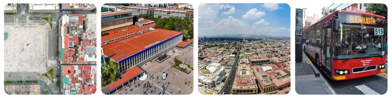
Quick, practical ways to travel from Mexico City Zócalo (Centro Histórico) to Buenavista Station (Metro + Tren Suburbano hub), with step-by-step routes, costs, and booking tips.
At A Glance (Mexico City Zócalo to Buenavista Station (Mexico City))
| Mode | Duration | Best For |
|---|---|---|
| 🚇 Metro (Line 2 → transfer → Line B) | ~25–45m (transfer-dependent) | Cheapest, predictable in traffic |
| 🏷️ Cost: ~MXN 5 per ride (plus a reusable card if you need one) | official Metro info | ||
| 🚌 Metrobús (Line 4 through Centro Histórico) | ~30–60m (traffic + stops) | Simple surface route, fewer stairs |
| 🏷️ Cost: ~MXN 6 (airport branch is higher) » official fare & payment | ||
| 🚕 Taxi / Ride-hailing / Private Transfer | ~15–35m (rush hour can double) | Door-to-door, luggage, groups |
| 🏷️ Cost: Taxi often ~MXN 120–250+ (time/traffic dependent) | » compare private rides | alt. prebook | ||
| 🚲 Bike (Ecobici) or Walk | Bike ~15–30m; walk ~45–70m | Daytime, light bags, scenic streets |
| 🏷️ Cost: Walk = free | Ecobici day pass ~MXN 127.99 » plans & rates | Bike rental comparisons » compare bikes | ||
Which Option or Route Should You Choose?
- Fastest (off-peak): Taxi / ride-hailing if you’re traveling with luggage or want door-to-door.
- Most economical: Metro (low fixed fare; best if you don’t mind stairs/corridors).
- Most straightforward on the surface: Metrobús Line 4 (great if you prefer fewer underground transfers).
- Most scenic & flexible: Bike / walk in daylight (stop for coffee, markets, photos).
How to Book and Practical Tips
- Use the same mobility card: CDMX Metro and Metrobús both use the city’s integrated fare system; keep a loaded card handy for quick entry (Metro + Metrobús official sites explain the system and payment).
- Expect occasional station closures near Zócalo: The Zócalo/Tenochtitlán area can close during major events; if it’s closed, walk to nearby stations like Allende or Pino Suárez and continue your route.
- Rush hour reality check: Weekday peaks (roughly 7:00–10:00 and 17:00–20:00) can slow buses and cars; Metro is usually the most time-stable.
- Keep small change and a backup plan: If you can’t get a ride-hailing pickup in the Zócalo core, walk a block or two to a wider avenue to request a car.
- Going onward from Buenavista: Buenavista is a major hub (Metro Line B + Metrobús connections, and the Tren Suburbano terminal for the Buenavista–Cuautitlán line). If you’re continuing by suburban rail, check schedules and fares first.
- Hands-free exploring: If you want to sightsee between check-out and departure, consider storing bags with luggage storage in Mexico City.

🚇 Option #1 — Metro (Cheapest, Predictable)
Lowest cost Traffic-proof Transfers & stairs
- Overview: Start at Zócalo/Tenochtitlán (Line 2) near Plaza de la Constitución, ride north to Hidalgo, transfer to Line 3 toward Indios Verdes, get off at Guerrero, then transfer to Line B and ride to Buenavista.
- Typical time: ~25–45 minutes depending on walking time in stations and platform waits.
- How to pay (with price): The Metro fare is historically MXN 5 per ride and is paid via the system’s ticket/card gates. See history of the Metro fare and service info on Metro CDMX.
- Pros: Cheapest and usually the most reliable in heavy traffic. Cons: Transfers can be long; some stations/corridors have stairs and crowds.
- Good to know: Buenavista is the terminal for Metro Line B and connects with other modes (official station page: Buenavista station).
Step-by-step: Metro route (Zócalo → Hidalgo → Guerrero → Buenavista)
- Find the Metro entrance at Zócalo: Use signage for Zócalo/Tenochtitlán near Plaza de la Constitución.
- Enter Line 2: Take Line 2 northbound (direction Cuatro Caminos).
- Ride to Hidalgo: Exit at Hidalgo and follow signs for Line 3 transfer.
- Transfer to Line 3: Board Line 3 toward Indios Verdes.
- Get off at Guerrero: Follow the in-station transfer signs to Line B.
- Take Line B to Buenavista: Ride to the end of the line and exit at Buenavista (use the official station info if you need exits and connections: Buenavista).
- Continuing by suburban rail: If your final target is the Tren Suburbano platforms, follow signs to the rail terminal and check Tren Suburbano for schedules and fares.
Getting to the main embarking points (Zócalo/Tenochtitlán station entrances)
- From the Zócalo square: Walk to the nearest “M” Metro sign around Plaza de la Constitución and follow signs for Línea 2.
- If the station is closed for an event: Walk to Allende (Line 2) or Pino Suárez (Lines 1/2) and start your journey from there, then follow the same transfer pattern toward Line B.
- Accessibility note: Some entrances and transfers involve stairs; allow extra time if you’re traveling with bulky luggage.
- Locations/Trip Planner: 🔗 Google Map / 🔗 OpenStreetMap
🚌 Option #2 — Metrobús Line 4 (Simple Surface Route)
Easy to follow Good for light luggage Traffic-dependent
- Overview: Walk from Zócalo to a nearby Metrobús Line 4 stop in Centro Histórico (commonly used stop: Museo de la Ciudad), then ride west/northwest toward Buenavista.
- Typical time: ~30–60 minutes, depending on traffic and how long you wait for the next bus.
- How to pay (with price): Standard Metrobús fare is MXN 6 (airport branch differs). See official Metrobús fare & payment.
- Pros: Fewer underground transfers; good if you prefer staying above ground. Cons: Slower in heavy traffic; boarding can be crowded.
- Route planning: Use the official system map and Line 4 map to confirm the stop you want today: Metrobús Line 4 map.
Step-by-step: Metrobús Line 4 (Centro Histórico → Buenavista)
- Walk to the closest Line 4 stop: From the Zócalo plaza, head toward a Line 4 stop such as Museo de la Ciudad (a common, walkable stop for the historic center area).
- Tap in and wait inside the station: Metrobús stations are gated; enter with your mobility card and wait on the platform.
- Board toward Buenavista: Confirm the bus direction on the platform screens/signage and ride to Buenavista.
- Exit at Buenavista hub: From the Buenavista Metrobús stop, follow signs for the Metro Line B station or Tren Suburbano terminal depending on where you’re going next.
Getting to the main embarking points (Line 4 stations near Zócalo)
- Nearest practical stops: Look for Line 4 stations around Centro Histórico such as Museo de la Ciudad; verify today’s stop/route using the Line 4 map.
- When Zócalo streets are pedestrianized: You may need to walk a few blocks to reach an open Line 4 station on a main corridor.
- Locations/Trip Planner: 🔗 Google Map / 🔗 OpenStreetMap
🚕 Option #3 — Taxi / Ride-hailing / Private Transfer (Most Convenient)
Door-to-door Best with luggage Traffic & pickup spots
- Overview: Book a regulated taxi or ride-hailing pickup near the Zócalo, then ride directly to Buenavista (Metro/rail hub). This is often the easiest choice with luggage or in a group.
- Typical time: ~15–35 minutes (rush hour and event closures can push it longer).
- Price range: City taxis are metered; ballpark for this cross-center trip is often ~MXN 120–250+ depending on traffic/time. Pre-booked transfers give you an upfront quote.
- How to book (with price):
- Prebook a private ride: Compare offers via GetTransfer (Mexico City) or arrange a driver via Welcome Pickups in Mexico City.
- Ride-hailing apps: Uber and DiDi are widely used in Mexico City; Cabify is another common option (availability can vary by neighborhood and time of day).
- Pros: No transfers; easiest with suitcases. Cons: Traffic can be unpredictable; pickups inside the Zócalo core can be tricky during closures.
Step-by-step: Taxi / ride-hailing pickup from the Zócalo
- Move to a wider street for pickup: If the Zócalo perimeter is crowded or restricted, walk 3–8 minutes to a main avenue (your driver will reach you faster).
- Set destination clearly: Enter “Metro Buenavista” or “Tren Suburbano Buenavista” depending on your exact endpoint.
- Allow buffer for traffic: If you must arrive by a specific time (train departure), add 15–20 minutes of cushion in peak periods.
- Arrive at the correct entrance: Buenavista is a big hub; confirm whether you need the Metro Line B, the Tren Suburbano terminal, or a particular exit.
Getting to the main embarking points (pickup zones around Zócalo)
- Best pickup strategy: Choose a pickup point on a through-street (not inside the closed pedestrian square) to reduce cancellations and wait time.
- Cash vs card: Ride-hailing is usually card-in-app; taxis may be cash-first depending on vehicle and circumstances.
- Late-night safety: Prefer app-based rides or trusted taxi stands; share your trip details with a companion if possible.
- Locations/Trip Planner: 🔗 Google Map / 🔗 OpenStreetMap
🚲 Option #4 — Bike (Ecobici) or Walk (Daytime, Scenic)
Flexible Great for sightseeing Weather & road comfort
- Overview: Walk the whole way, or use a short Ecobici ride (dock-to-dock) to reach Buenavista quickly without dealing with traffic jams.
- Typical time: Bike ~15–30 minutes; walk ~45–70 minutes (pace and stoplights matter).
- How to book (with price):
- Ecobici: Buy a pass (tourist-friendly) and use the app/dock to unlock bikes. Current day plans are listed on Ecobici plans and rates.
- Traditional bike rentals: Compare providers via bike rentals in Mexico City.
- Pros: You can stop at landmarks en route; often faster than driving in clogged Centro. Cons: Not ideal with heavy luggage; use extra caution with traffic and road conditions.
- Extra idea: If you want to turn the walk into a mini-sightseeing route, browse Historic Center of Mexico City tours for guided context before heading to Buenavista.
Step-by-step: Bike/walk route basics
- Decide walk vs bike: If you have bags, consider storing them first via luggage storage in Mexico City.
- For Ecobici: Purchase a plan and locate a nearby dock using the Ecobici map in the app/site.
- Ride to Buenavista area: Aim for docks near the Buenavista hub, then walk the last few minutes to the Metro/suburban rail entrance.
- For walking: Keep to well-lit main streets, especially at night, and allow extra time for crossings.
Getting to the main embarking points (Ecobici docks around Zócalo)
- Where to start: Look for the nearest Ecobici dock around Centro Histórico and unlock a bike with your pass.
- Safety basics: Ride defensively, avoid phone-in-hand navigation, and prefer calmer streets if you’re not used to Mexico City traffic.
- Locations/Trip Planner: 🔗 Google Map / 🔗 OpenStreetMap
FAQ (Mexico City Zócalo to Buenavista Station (Mexico City))
What’s the easiest way to get from Mexico City Zócalo to Buenavista Station?
For most travelers, the Metro is the easiest mix of low cost and reliability; if you have luggage or want door-to-door, use taxi/ride-hailing.
How much does the Metro cost and how do I pay?
The Metro fare is widely published as MXN 5 per ride and you enter through turnstiles using the system’s ticket/card gates; see Metro fare history for official context.
How much does Metrobús cost?
The standard fare is MXN 6, paid by tapping in at Metrobús stations; confirm details on Metrobús fare & payment.
What if the Zócalo Metro station is closed?
During major events, Zócalo/Tenochtitlán can close. Walk to nearby stations like Allende or Pino Suárez and continue by Metro, or use Metrobús Line 4 from a nearby open station.
Is Buenavista the same place for Metro and the Tren Suburbano?
They connect in the same hub area: Buenavista is the terminal station for Metro Line B and also the terminal for the Tren Suburbano Buenavista–Cuautitlán line; check Metro Buenavista and Tren Suburbano for details.
Which option is best with luggage?
Choose taxi/ride-hailing or a prebooked transfer to avoid stairs and station corridors. If you need to explore hands-free before your train, consider luggage storage in Mexico City.
Related Tours/Services
Popular Routes
Recent Routes
- How to get from London Stansted Airport to Covent Garden
- How to get from Santiago International Airport (SCL) to Valparaíso Cruise Terminal
- How to get from Venice Marco Polo Airport to St Mark’s Square
- How to get from Milan Malpensa Airport to Duomo di Milano
- How to get from Rome Ciampino Airport to Colosseum
- How to get from Casablanca Mohammed V Airport to Medina of Casablanca
- How to get from Stanley Park to Vancouver Pacific Central Station
- How to get from Golden Gate Bridge to San Francisco 4th & King Station
- How to get from Lagos Murtala Muhammed Airport to Lekki Conservation Centre
- How to get from Alhambra (Granada) to Granada Railway Station
Top Travel Gears
FYY Travel Cable Organizer Pouch Electronic Accessories Carry Case Portable Waterproof Double Layers All-in-One Storage Bag for Cord, Charger, Phone, Earphone Black

MiiKARE Airplane Travel Essentials Phone Holder, Universal Handsfree Phone Mount for Flying with 360 Degree Rotation, Accessory for Airplane, Travel Must Haves Phone Stand for Desk, Tray Table

LISEN Airplane Travel Essentials for Women Men Phone Holder for Desk Cruise Vacation Essentials 2026 MagSafe Travel Size Accessories Flying Long Flight Airplane Gadgets Men Father Gifts

Travel Utensils with Case, Quatish Portable Silverware Set for Work, Stainless Steel Reusable Travel Cutlery Set, Fork and Spoon Set for Camping, Picnic, Gadgets, Lunch Box for Men, Black
