

How to get from Kpalimé to Mount Agou (Togo)

Mount Agou, traditionally considered Togo’s highest mountain at 986 meters, is a popular hiking destination southeast of Kpalimé. Located approximately 17–20 km from town, it can be reached by private taxi, motorcycle taxi, local shared transport, or an organized hiking excursion. This guide covers transportation options, estimated costs, trail access, summit restrictions, and practical travel tips.
At A Glance (Kpalimé to Mount Agou (Togo))
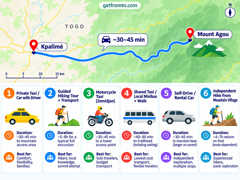
| Mode | Duration | Best For |
|---|---|---|
| 🚕 Private Taxi / Car with Driver | ~30–45m to mountain access area; longer to upper slopes | Comfort, flexibility, families |
| 🏷️ Cost: Budget ~XOF 10,000–25,000 for a negotiated return transfer; waiting, upper-road access, and permits may cost extra | ||
| 🥾 Guided Hiking Tour + Transport | ~5–8h for a typical full excursion | Hikers, local knowledge, summit attempt |
| 🏷️ Cost: Local guide ~XOF 5,000–12,000 per group for basic guiding; transport, permits, and longer tours extra | ||
| 🏍️ Motorcycle Taxi (Zemidjan) | ~30–45m to a lower mountain access point | Solo travelers, budget transport |
| 🏷️ Cost: Allow ~XOF 3,000–7,000 one-way as a negotiation budget; return and waiting extra | ||
| 🚌 Shared Taxi / Local Minibus + Walk | ~40–90m to trailhead including waiting and onward travel | Lowest-cost transport, flexible travelers |
| 🏷️ Cost: Allow ~XOF 500–2,000 for the shared-road segment, plus any motorcycle transfer or guide fee | ||
| 🚗 Self-Drive / Rental Car | ~30–45m to mountain base; longer on winding ascent roads | Independent exploration, multiple stops |
| 🏷️ Cost: Budget ~XOF 25,000–60,000+ per day for a rental where available, excluding fuel, deposits, and local charges | ||
| 🚶 Independent Hike from Mountain Village | ~4–7h return on foot from a lower trailhead, route-dependent | Experienced hikers, scenic exploration |
| 🏷️ Cost: No fixed hiking transport fare; budget for access permission, any local charges, and optional guiding | ||
Which Option or Route Should You Choose?
- Fastest and most convenient: A private taxi or car with driver is the easiest option for reaching Mount Agou from Kpalimé, especially if you want to visit viewpoints without undertaking a full hike.
- Best for reaching the summit on foot: A guided hiking excursion combines local trail knowledge, transportation, and assistance with access arrangements. It is the recommended choice for first-time visitors.
- Cheapest individual transfer: A zemidjan motorcycle taxi offers affordable transportation toward the mountain villages and trailheads, although it may not be suitable for the steepest upper roads.
- Lowest-cost public transport: A shared taxi or local minibus can bring you to the Agou area, followed by walking or a motorcycle connection. This requires flexibility and local directions.
- Most flexible for sightseeing: A rental car allows additional stops at villages, plantations, and other attractions around Kpalimé. Confirm road conditions and vehicle suitability before attempting the mountain ascent.
- Most adventurous: An independent hike from an established mountain access village suits experienced hikers familiar with navigation and local conditions, provided required permission has been obtained.
How to Book and Practical Tips
- Confirm summit permission: Mount Agou has communications and security installations near the summit. Togo’s official tourism information states that access to the site is subject to authorization. Ask a local tourism office, authorized guide, or relevant authorities about current permission requirements before attempting the ascent.
- Start early: Leave Kpalimé around 6:00–8:00 AM for a full hiking excursion. Early departures help avoid the hottest part of the day and may provide better visibility before afternoon clouds develop.
- Hire a local guide for hiking: Guides can help with trail navigation, village access, local customs, and any applicable checkpoints. Confirm the route, total duration, guiding price, and return transportation in advance.
- Carry West African CFA francs: Bring small XOF notes for motorcycle taxis, shared vehicles, guides, food, and any authorized local access payments. Do not assume card payments will be accepted.
- Prepare for a steep climb: Wear shoes with good grip and bring at least 1.5–2 liters of water per person, snacks, sunscreen, a hat, and rain protection. Trails may become slippery during the rainy season.
- Choose transport suitable for mountain roads: The mountain has an established access road, but sections can be steep and winding. Ask whether the driver can safely reach your intended viewpoint or trailhead rather than assuming every vehicle can reach the summit.
- Arrange return transportation: Shared vehicles and motorcycle taxis may be difficult to find near remote trailheads. If traveling independently, agree on a return pickup location and time before departure.
- Plan accommodation and additional activities: Kpalimé is a convenient overnight base for Mount Agou. Travelers can also check hiking and nature activities in Togo, although dedicated Mount Agou excursions may have limited online availability.
🚕 Option 1 — Private Taxi / Car with Driver (Most Convenient)
Flexible schedule Comfortable Access permission required
- Overview: A private taxi is the most straightforward way to travel from Kpalimé to Mount Agou. The mountain lies approximately 17–20 km southeast of town, with a typical 30–45-minute drive to the lower mountain access area. Most drivers follow the main road toward Agou before continuing along smaller roads toward villages such as Agou-Gadzépé or Agou-Nyogbo. The winding mountain road may allow access to higher viewpoints, but the final destination depends on road conditions, vehicle capability, and permission to enter restricted areas.
- How to book (with price): Ask your accommodation in Kpalimé to arrange a taxi or negotiate directly with a local driver. Allow approximately XOF 10,000–25,000 for a basic negotiated return transfer as an initial budget, with extra charges possible for extended waiting, rough-road driving, or a longer sightseeing itinerary. This is not a published tariff. Travelers can also request a quotation through GetTransfer, although local vehicle availability is not guaranteed. Confirm whether the price includes waiting while you hike.
- Pros: Comfortable, flexible, suitable for groups and families, and useful for visiting accessible viewpoints without completing the entire ascent. Cons: Higher cost than shared transport, potentially limited access to upper roads, and the need to arrange local authorization separately.
Step-by-step: Private Taxi / Car with Driver
- Arrange a vehicle in Kpalimé: Contact your guesthouse, hotel, or a recommended local taxi driver. Explain that you want to visit Mount Agou rather than simply travel to Agou village.
- Confirm the exact destination: Decide whether you want to reach a lower mountain trailhead, visit accessible hillside villages, or travel toward the upper summit road. Ask the driver which locations are currently accessible.
- Check access requirements: Before leaving, ask whether advance authorization is required for your intended route and whether the driver can assist you in contacting the relevant local authorities.
- Leave Kpalimé: Travel southeast toward the Agou area on the main road connecting Kpalimé with communities farther south.
- Continue toward the mountain: Follow the appropriate local road toward the agreed village or trailhead. Expect winding roads, plantations, and hillside settlements.
- Stop at authorized viewpoints: Take photographs and enjoy views of the surrounding Plateaux Region where stopping is permitted. Avoid entering communications installations or restricted compounds.
- Return to Kpalimé: Meet your driver at the agreed location and return along the same general road network. A sightseeing visit may take 2–4 hours overall, while adding a summit hike can turn it into a full-day excursion.
Getting to the main pickup points (Kpalimé Town Center)
- Kpalimé central market: The town center and surrounding streets are useful places to find local transport or arrange a meeting with a taxi driver.
- Kpalimé hotels and guesthouses: Ask reception for a direct pickup, which is generally more convenient than finding transport independently.
- Main road toward Agou: Drivers leave Kpalimé toward the Agou area before taking the local mountain approach road.
- Mountain access villages: Confirm the intended trailhead with your driver. Agou-Gadzépé, Agou-Nyogbo, and Agou-Tomégbé are names travelers may encounter, but they are not interchangeable pickup points.
- Locations/Trip Planner: 🔗 Google Map / 🔗 OpenStreetMap
🥾 Option 2 — Guided Hiking Tour + Transport (Best for Summit Exploration)
Local guide Nature and culture Moderate to challenging
- Overview: A guided hike is one of the best ways to experience Mount Agou’s forested slopes, coffee and cocoa plantations, hillside settlements, and panoramic viewpoints. Guided routes commonly begin from a village or trailhead on the mountain rather than from Kpalimé itself. A full lower-trailhead ascent can involve approximately 4–6 hours of walking, with longer excursions taking 6–8 hours including transport and breaks. Shorter walks are possible from higher access points. The exact summit area contains restricted infrastructure, so reaching the highest point requires appropriate authorization.
- How to book (with price): Arrange a guide through your accommodation, a Kpalimé-based tourism operator, or a local guide association. Basic local guiding has been reported at approximately XOF 5,000–12,000 per group, but a full-day organized hike with transportation, assistance with permissions, and additional services can cost substantially more. Confirm what is included before paying. You can consult Togo’s official Kpalimé tourism information for details about the region’s mountain attractions.
- Pros: Local trail expertise, cultural insights, easier navigation, assistance with access arrangements, and more opportunities to learn about regional plants and village life. Cons: Additional guide and transport costs, physically demanding climbs, and possible restrictions near the summit.
Step-by-step: Guided Mount Agou Hike
- Choose the hiking itinerary: Decide whether you prefer a shorter village-and-viewpoint walk or a longer mountain ascent. Explain your fitness level and available time to the guide.
- Confirm access permission: Ask the guide to verify the current rules for your planned trail and summit access. Do not assume a guide’s presence automatically grants entry to restricted areas.
- Meet your guide in Kpalimé: Arrange collection from your accommodation or a central meeting point, preferably early in the morning.
- Travel to the starting village: Drive approximately 30–45 minutes toward the mountain access area, using the trailhead selected by your guide.
- Begin the ascent: Follow established local paths or mountain-road sections through cultivated hillsides, forest patches, and settlements. The route may include steep or rocky stretches.
- Take planned rest stops: Drink water regularly and pause at safe viewpoints. Your guide may explain local agriculture, plants, and the history of communities living on the mountain.
- Reach the permitted upper viewpoint: If summit access has been authorized, continue according to local instructions. Otherwise, enjoy the highest publicly accessible viewpoint on your chosen route.
- Descend and return: Follow the arranged descent route to the vehicle pickup point, then travel back to Kpalimé. Allow a full day for a longer hike.
Getting to the main embarking points (Kpalimé Hotels and Agou Trailheads)
- Kpalimé accommodation: Many guided excursions can begin with hotel pickup. Confirm the meeting time and whether transportation is included.
- Kpalimé town center: If your tour does not include hotel pickup, arrange to meet the guide near an identifiable central landmark.
- Agou-Nyogbo and nearby villages: These are possible access areas for hikes on the mountain’s slopes. The actual starting point depends on the chosen route and local permissions.
- Upper mountain road: Some shorter hikes may begin at a higher road-accessible point, reducing the ascent distance. Access and parking must be confirmed locally.
- Locations/Trip Planner: 🔗 Google Map / 🔗 OpenStreetMap
🏍️ Option 3 — Motorcycle Taxi / Zemidjan (Affordable and Flexible)
Budget-friendly Flexible departure Limited luggage
- Overview: Motorcycle taxis, commonly called zemidjans, are widely used for local transportation in Togo. From Kpalimé, a motorcycle taxi can take individual travelers toward the Mount Agou foothills or a suitable mountain village. The journey generally takes 30–45 minutes to a lower access point, depending on road conditions. Continuing farther uphill may require a different vehicle, walking, or a specialized local arrangement.
- How to book (with price): Find a motorcycle taxi around Kpalimé’s central streets, local transport stands, or through your accommodation. Budget approximately XOF 3,000–7,000 one-way as a starting negotiation range for a longer ride toward the Agou area, not a fixed fare. Expect additional charges for waiting or difficult roads. Local ride-hailing app coverage is not dependable for this route, so arranging a known driver directly is usually more practical.
- Pros: Relatively affordable, useful for solo travelers, flexible pickup locations, and practical for reaching smaller settlements. Cons: Exposure to weather and traffic, limited space for hiking equipment, and increased risk on steep, wet, or poorly maintained roads.
Step-by-step: Motorcycle Taxi / Zemidjan
- Find a reliable driver: Ask your hotel or guesthouse to recommend a local motorcycle taxi operator familiar with the Agou area.
- Explain the exact destination: Specify the name of your intended mountain village or trailhead. Simply asking for Mount Agou may lead to confusion about how far uphill you want to travel.
- Confirm the fare: Agree on the price in XOF and clarify whether the driver will wait, return later, or provide a one-way transfer only.
- Check the motorcycle: Wear a properly fitting helmet and avoid overloaded or poorly maintained motorcycles. Do not ride if conditions are unsafe.
- Depart Kpalimé: Travel toward the Agou area along the main road before turning toward the agreed mountain access village.
- Continue to the trailhead: Stop at a safe, accessible location where the driver can drop you off without entering restricted areas.
- Begin your hike or sightseeing: Follow your planned walking route with the necessary authorization and local guidance.
- Return to Kpalimé: Use your prearranged pickup or contact your driver after the activity. Mobile coverage may be inconsistent in some mountain areas, so agree on a meeting time beforehand.
Getting to the main pickup points (Kpalimé Motorcycle Taxi Stands)
- Kpalimé central market area: Motorcycle taxis can commonly be found along busy commercial streets near the town center.
- Main transport routes: Ask locally where zemidjans serving villages outside Kpalimé are available.
- Hotels and guesthouses: Staff can often call a trusted driver to collect you from your accommodation.
- Agou mountain access villages: Confirm a named stopping point and avoid requesting transport onto roads unsuitable for motorcycles.
- Locations/Trip Planner: 🔗 Google Map / 🔗 OpenStreetMap
🚌 Option 4 — Shared Taxi / Local Minibus + Walk (Lowest-Cost Motorized Option)
Low cost Local experience Connection-dependent
- Overview: Shared taxis and local minibuses operate along roads connecting Kpalimé with nearby towns and villages. Travelers may be able to board a vehicle heading toward the Agou area and get off at a suitable junction or village before continuing on foot or by motorcycle taxi. There is no dependable scheduled public bus directly to the Mount Agou summit. Allow approximately 40–90 minutes to reach a usable trailhead, depending on the vehicle, waiting time, and onward connection.
- How to book (with price): Ask at the local shared-taxi departure area in Kpalimé for a vehicle passing the appropriate Agou village or turn-off. A short shared-road segment may cost approximately XOF 500–2,000 per person as a planning allowance, with onward transport charged separately. Confirm the destination and fare with the driver before boarding. There is no need to book a long-distance bus or use an international transport platform for this short local trip.
- Pros: Very economical, offers a local travel experience, and useful for travelers on flexible schedules. Cons: Unpredictable departures, indirect connections, limited luggage space, and potentially substantial walking from the main road to the trailhead.
Step-by-step: Shared Taxi / Local Minibus + Walk
- Locate the local transport departure area: Ask your accommodation for the current shared-taxi or minibus pickup point serving villages southeast of Kpalimé.
- Identify the correct vehicle: Look for transport heading toward the Agou area. Confirm whether it passes your intended village, such as Agou-Tomégbé or an appropriate junction for the mountain.
- Confirm the drop-off: Tell the driver that your final destination is Mount Agou and ask where you should change to a motorcycle taxi or begin walking.
- Pay the local fare: Carry small XOF notes, confirm the fare in advance, and avoid assuming that all shared taxis charge the same amount.
- Travel toward Agou: Follow the main road southeast from Kpalimé and disembark at the agreed village or mountain access junction.
- Arrange the final connection: Find a local motorcycle taxi or walk toward the trailhead if the distance and road conditions are suitable.
- Confirm hiking access: Check applicable local permissions before continuing onto mountain paths or restricted upper-road sections.
- Plan the return: Ask residents or local drivers about the last practical shared transport back to Kpalimé. Do not rely on a fixed published timetable.
Getting to the main embarking points (Kpalimé Shared Transport Area)
- Kpalimé central transport area: Ask near the central market and local taxi stands for vehicles heading toward Agou and surrounding villages.
- Roadside shared-taxi stops: Some services collect passengers along main roads rather than at a formal station. Confirm the correct pickup point locally.
- Agou-area villages: The most useful drop-off depends on the hiking route. Agou-Tomégbé and Agou-Nyogbo may serve different approaches.
- Mountain access roads: The final approach can be steep and may require walking or a separate motorcycle ride. Confirm the distance before leaving the shared vehicle.
- Locations/Trip Planner: 🔗 Google Map / 🔗 OpenStreetMap
🚗 Option 5 — Self-Drive / Rental Car (Best for Flexible Sightseeing)
Independent travel Multiple stops Mountain-road caution
- Overview: Self-driving allows travelers to explore Mount Agou and the surrounding Plateaux Region without depending on local transport schedules. From Kpalimé, follow the road toward the Agou area and continue to an accessible mountain village or viewpoint. The drive to the foothills generally takes 30–45 minutes. Although a mountain access road exists, the upper route may be steep, winding, or unsuitable for some rental vehicles, and access restrictions can apply.
- How to book (with price): Rental availability within Kpalimé itself can be limited, so travelers may need to arrange a vehicle in Lomé before arriving. Allow approximately XOF 25,000–60,000 or more per day as a preliminary rental budget, depending on vehicle class and provider. Check Booking.com car rental for available pickup locations in Togo. Confirm the correct driving documents, insurance coverage, deposit, and permission to use rural or mountain roads.
- Pros: Maximum flexibility, practical for families or groups, and convenient for combining Mount Agou with plantations, villages, and waterfalls. Cons: Rental costs, unfamiliar local driving conditions, possible navigation difficulties, and restrictions on certain upper mountain roads.
Step-by-step: Self-Drive / Rental Car
- Arrange the rental vehicle: Reserve a suitable car in advance, particularly if you require pickup outside Lomé. A vehicle with reasonable ground clearance may be more practical on rough access roads.
- Verify driving requirements: Confirm that your license and any required international driving documentation are accepted, and check insurance coverage for the intended route.
- Check access arrangements: Contact a local tourism guide or relevant authority about permitted mountain roads and viewpoints before departure.
- Depart from Kpalimé: Follow the main road southeast toward Agou and use your chosen village or trailhead as the navigation destination.
- Approach the mountain carefully: Reduce speed on winding roads and watch for pedestrians, motorcycles, animals, and uneven surfaces.
- Park at an authorized location: Leave the car in a suitable village or trailhead parking area if you plan to hike. Do not attempt to drive through restricted checkpoints.
- Explore the mountain: Walk to accessible viewpoints, arrange a local guide for a longer trail, or visit surrounding plantations and villages where permitted.
- Return before dark: Drive back to Kpalimé with enough daylight to navigate unfamiliar rural roads safely.
Getting to the main departure points (Kpalimé and Lomé Rental Locations)
- Kpalimé town center: Begin your drive from your hotel or a local rental pickup point if a suitable vehicle is available.
- Lomé rental offices: Travelers planning a longer trip may find more rental choices in the capital and drive to Kpalimé before visiting Mount Agou.
- Agou access road: Follow the road toward the agreed mountain village or viewpoint rather than attempting to navigate directly to the summit coordinates without checking road access.
- Trailhead parking: Ask local residents or your guide where visitors may safely leave vehicles during a hike.
- Locations/Trip Planner: 🔗 Google Map / 🔗 OpenStreetMap
🚶 Option 6 — Independent Hike from Mountain Village (Most Adventurous)
Scenic trails Flexible pace Experienced hikers
- Overview: Experienced hikers can explore Mount Agou’s lower and middle slopes from an appropriate mountain village, provided that local access rules permit the route. The hiking experience includes cultivated hillsides, winding tracks, forest vegetation, and viewpoints across the Plateaux Region. A longer ascent from a lower trailhead can involve approximately 4–7 hours of walking return, depending on the route and conditions. Full excursions from Kpalimé may take most of the day. This option refers to traveling by local transport to a trailhead and hiking independently, not walking the entire road distance from Kpalimé.
- How to book (with price): Arrange transportation to a suitable Agou-area village and verify current access regulations before starting. Walking itself has no fixed transport fare, but local access charges or authorization requirements may apply. Hiring a local guide remains strongly recommended, with basic guiding sometimes quoted around XOF 5,000–12,000 per group. Do not enter the summit security area without explicit authorization.
- Pros: Flexible walking pace, opportunities to explore mountain scenery, inexpensive when properly arranged, and rewarding for experienced hikers. Cons: Unmarked or confusing trails, steep sections, limited facilities, changing weather, and restricted summit access.
Step-by-step: Independent Mount Agou Hike
- Research the hiking approach: Identify an established trail beginning near an Agou-area village. Confirm the intended route and current conditions with local residents or tourism representatives.
- Arrange local access: Check whether authorization, registration, or a local escort is necessary. If restrictions cannot be clarified, use an organized guided excursion instead.
- Travel from Kpalimé: Take a taxi, motorcycle taxi, or shared transport toward the selected village or trailhead.
- Prepare your equipment: Carry drinking water, snacks, offline maps, a charged phone, sun protection, rain gear, and footwear suitable for steep or slippery paths.
- Start early: Begin walking in the morning and allow generous time for the ascent, rest stops, and descent before sunset.
- Follow permitted paths: Stay on established routes, respect private farmland and village areas, and avoid entering restricted installations or passing unauthorized checkpoints.
- Enjoy the viewpoints: Stop at safely accessible locations to see the surrounding hills and cultivated valleys. Views toward Ghana may be possible in clear weather.
- Descend and return: Follow your planned route back to the starting village and meet your prearranged transportation to Kpalimé.
Getting to the main hiking starting points (Agou Mountain Villages)
- Agou-Nyogbo: An approach area used for hiking toward Mount Agou. Confirm the specific trailhead and accessibility before traveling.
- Agou-Gadzépé: Another village associated with mountain approaches. Local directions are important because not every village path connects directly to the same hiking route.
- Agou-Tomégbé: A settlement near the mountain that can be useful for orientation and local transport connections, depending on the intended trail.
- Upper access road: Some visitors begin shorter hikes from higher locations, but available trails and permission requirements may differ from lower village approaches.
- Important: A navigation app may show the mountain’s geographic summit rather than a safe pedestrian trail. Do not interpret straight-line map directions as a verified hiking route.
- Locations/Trip Planner: 🔗 Google Map / 🔗 OpenStreetMap
FAQ (Kpalimé to Mount Agou (Togo))
How far is Mount Agou from Kpalimé?
Mount Agou is approximately 17–20 km southeast of Kpalimé, depending on the destination and route used. A taxi typically takes 30–45 minutes to reach the lower mountain access area. Continuing uphill or reaching a particular trailhead may take longer.
Can you drive to the top of Mount Agou?
Mount Agou has a road approaching the summit area, and some visitors reach upper viewpoints by vehicle. However, road conditions vary and the summit contains communications and security installations. Access is restricted, and authorization may be required. Confirm current road access and official permission before attempting to drive to the top.
Do you need a guide to climb Mount Agou?
A local guide is strongly recommended, especially for first-time visitors and those using village trails. A guide can help with navigation, access procedures, and local information. Guiding requirements may depend on the route and current regulations, and hiring a guide does not replace any necessary official authorization.
How long does it take to hike Mount Agou?
A typical longer ascent from a lower village trailhead may take approximately 4–7 hours return on foot. Shorter walks are possible from higher access points. Including travel from Kpalimé, breaks, and sightseeing, plan approximately 5–8 hours or a full day for a substantial hiking excursion.
What is the cheapest way to get from Kpalimé to Mount Agou?
Shared taxis or local minibuses traveling toward the Agou area are generally the cheapest motorized option. Allow approximately XOF 500–2,000 for a shared-road segment, followed by walking or an additional motorcycle taxi. For solo travelers, a direct motorcycle taxi may be more convenient but costs more.
When is the best time to visit Mount Agou?
The drier months, particularly November through February or March, generally offer more manageable hiking conditions, although harmattan haze can reduce visibility. Rainy periods bring lush greenery but also slippery trails and cloudy viewpoints. Early morning is usually the best time to begin a hike.





Related Tours/Services
Popular Routes
Recent Routes
- How to get from Kpalimé to Mount Agou (Togo)
- How to get from Blantyre to Mount Mulanje (Malawi)
- How to get from Cape Coast to Elmina Castle
- How to get from Lagos to Abeokuta (Nigeria)
- How to get from Khorog to Murghab
- How to get from Cozumel Puerta Maya Cruise Terminal to Chankanaab Beach Adventure Park
- How to get from Nassau Cruise Port to Atlantis Paradise Island
- How to get from Whittier Cruise Terminal to Anchorage
- How to get from Kotor Cruise Port to Budva
- How to get from Dubrovnik Gruz Cruise Port to Dubrovnik Old Town
Top Travel Gears

travel inspira Luggage Scale Digital Suitcase Weight Scale for Travel | Blue Backlight, Rubber Paint Handle, Tare & Data Lock, Auto-Off, Battery Included, 110 Pounds, Travel Essentials

LISEN Airplane Travel Essentials for Flying Airplane Phone Holder for Desk Phone Stand Hands Free MagSafe Travel Accessories Long Flight Travel Tech Halloween Decorations Gifts for Men

zelin Anti Theft Zipper Clips, Travel Essentials, Carabiner, 4Pcs Grey | Elegant Zinc Alloy Zipper Pull Locks, Airplane Gadgets and Travel Accessories for Backpacks, Commuting and Outdoor Safety

2026 Travel Essentials for Apple Watch Charger,Cruise Vacation Camping Essentials,iPhone Charger,Multi Charging Cable,3 in 2 Charging Docks for iWatch Series 12 11-2/Ultra,iPhone 18 17-12,Car
FYY Electronic Organizer, Travel Tech Pouch Bag, Cable Organizer Black | Wrist Strap, Waterproof, Double Layers Portable Electronics Travel Carrying Case for Cord, Charger, Daily Business Trips Use
